
Lidar: Uses and Technology Explained

Lidar – which stands for “light detection and ranging” or “laser imaging, detection, and ranging” – is a type of remote sensing technology that uses pulsed laser light to measure distances and to create detailed three-dimensional images of terrain or objects.
Lidar Technology and Operation
Lidar is similar to radar in terms of its fundamental principle, but instead of using sound waves, it utilizes laser light. Radar systems emit radio waves that bounce off objects or terrain and return to the radar antenna. Lidar systems pulse laser light toward an object or terrain. By measuring the time it takes for the light to return and analyzing the properties of the reflected light, such as intensity and wavelength, lidar can determine distances, shapes, and surface characteristics.
In principle lidar systems operate the same way, but the differences between the characteristics of light and the characteristics of radio waves generate different results. Because light has significantly shorter wavelengths than radio waves, lidar is much better at identifying small objects and is better at capturing fine details. However, radar has a significantly longer range than lidar, and can penetrate most weather conditions. Generally, then, lidar provides higher resolution and is more accurate in capturing fine details, while radar has a much longer range, and is not limited by weather conditions.
Take the image of Mt. St. Helens below as an example. The image on the left was created using radar imaging while the image on the right was created using lidar imaging. As you can see, the lidar image has a much higher resolution and is significantly more detailed than the radar image.

A lidar system typically includes three main components: a laser source, a scanner, and a detector. The laser source releases laser pulses which travel until they encounter an object or terrain feature and are reflected toward the lidar system. The returning light is collected by the scanner and directed into the detector. The detector is a very sensitive instrument that detects the amount of time light takes to travel back and forth between the lidar system and the object. Because the speed of light is constant, the time between the laser emission and reflection into the detector provides useful data regarding distance.
Lidar Industry Applications
Lidar is used in a wide variety of industries including:
Autonomous Vehicles – Lidar is a crucial component of autonomous vehicle platforms. Beyond general navigation and pathing, lidar systems allow the detection and tracking of pedestrians, obstacles, and other vehicles, ensuring safe movement in complex environments. Lidar is often paired with other sensor technologies, such as cameras and radar, to provide a comprehensive and robust system for autonomous vehicles.
Mapping – Lidar has completely transformed the process of both topographic mapping and bathymetry – the study of ocean, lake, or river floors, essentially underwater topography. Because airborne lidar systems can cover huge areas rapidly and efficiently, it has become the default topographic mapping technique. Lidar can capture elevation data accurate to 10 cm, making it perfect for applications like environmental assessments and infrastructure planning. Although there are limits to how deeply light can penetrate water, lidar is being used by organizations like the NOAA to map shorelines and shallow coastal waters. NOAA also offers a wide variety of open, publicly available lidar data for download and use.
Agriculture and Forestry – Lidar technology helps with a wide variety of forestry-related tasks, especially in remote areas that are difficult to reach like the depths of the Amazon Rainforest. Specifically, lidar is used to assess the health, composition, and biomass of forests. Lidar can penetrate through the tree canopy and provide detailed information on the vertical structure and density of forests, allowing researchers to estimate tree height, crown diameter, and leaf area index. This data is used to monitor forest health, manage resources, and support conservation efforts.
Precision agriculture relies on data, and lidar can provide a litany of different data points. Lidar is used to gather plant and crop data, from the height and density of a single plant, all the way to an entire field. Further, lidar can be used to monitor crop growth and detect the need for pruning or other maintenance, detect variations in fruit or crop production, or simply count plants. In one of the most novel uses of the technology, in 2017 a Scandinavian research team patented a process by which lidar can be used to detect insects and identify the sex and species of individual insects.
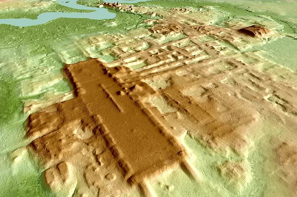
Archaeology – Archaeology may be the field most affected by lidar technology. In scanning large areas from the air or ground, lidar reveals subtle features of the terrain, like long-buried structures or ancient ruins, that may not be easily visible to the naked eye. Lidar scans uncovered the largest and oldest Maya structure known, Aguada Fénix. Located near the Mexico/Guatemala border, this discovery is significantly impacting the study of the Mayan civilization.
Ultimately, lidar is a precision tool for applications that require a high degree of accuracy. The technology is perfect for things like 3D mapping and surveying. The precision also makes lidar technology a good choice for machine vision systems and autonomous vehicle navigation.
Whatever the use case, lidar deployment is growing rapidly. According to an April 2023 Spherical Insights report, the global lidar market was valued at around $1.5 billion in 2021. Spherical Insights projects the lidar market to grow rapidly, reaching around $4.83 by 2030.
Categories: